Cardiff landscape, 1678
This is one of the earliest images of Wales drawn 'on the spot' that the Museum has in its collections. Sketched by Francis Place in 1678 as two separate views, Amgueddfa Cymru has digitally scanned and stitched the two sketches together to reveal for the first time this unique view of Cardiff as seen in 1678.
Landmark descriptions:
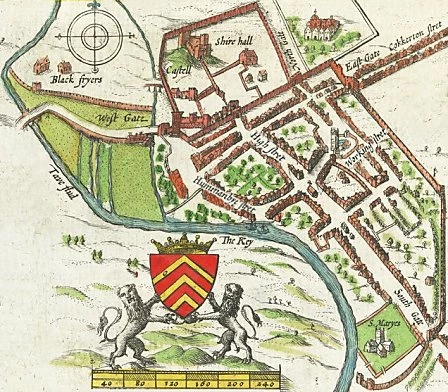
John Speed's map of 1610. Speed's plan of Cardiff reveals many aspects of the city's development, including the majority of features described in this article.
-
Cardiff Castle
In the 15th century the town was destroyed by Owain Glyndŵr's Welsh army. The Castle lay in ruin until Richard Beauchamp, Earl of Warwick, restored the defences and castle buildings in 1423. Beauchamp also constructed the octagonal tower, now known as Beauchamp's tower. -
St John's Church
In the centre of Cardiff stands St John's church. Its earliest surviving stonework is mid 13th century and its tower was added around the 1470s, however, much of the church we see today was rebuilt during the 18th century. -
Walls of Cardiff castle
During the medieval period, building plots were packed so tight against the old Roman wall, that some of the inhabitants were forced to extend their homes backwards through it. -
Beauchamp's Tower
Built in the 15th century, to protect the castle's west gate. Openings at the top of the tower allowed stones or burning objects to be dropped on attackers (The unusual decorative spire we see today was not added until the 19th century). -
The quay
The river Taff was a major influence on the shape of medieval Cardiff. Up until the 1840s, the river meandered slowly southward. By 1610, the river has reached Hummanbye [Womanby] Street -
Medieval Cardiff
The medieval town spread out from the Castle's South Gate. Interestingly the High Street lines up with the Roman rather than the medieval South Gate, suggesting it dates from this earlier period.
The Medieval town probably developed in two stages. The first stage was within a relatively small enclosure marked out by Working Street and Womanby (Hummanbye) Streets' both names are linked to old Norse. In the second stage of its development, Cardiff expanded south. The town was then enclosed and defended to the east by a bank and ditch and eventually a stone gate. To the west, the town was protected by the meandering river Taff. -
St Mary's Church
At the southern end of the medieval town was St Mary's church. By 1610, the meandering river Taff had reached Hummanbye [Womanby] Street, and was beginning to disrupt the church of St Mary. By the early 19th century, the church has been completely destroyed, and today only the name of the church is left as a street name.

