Gelligaer Roman fort
Roman Military network
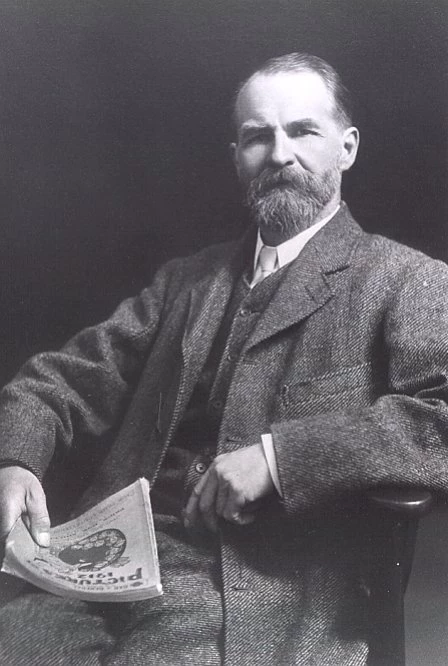
John Ward, Curator of Cardiff Museum and Art Gallery (1893-1912) and first Keeper of Archaeology in the National Museum of Wales (1912-14).
For over 40 years Gelligaer was a cornerstone of the Roman military network that controlled south-east Wales.
The fort at Gelligaer is sited on a ridge between the Taff and Rhymney valleys. It commands an extensive view of this upland region, which was heavily wooded in Roman times.
The fort, constructed in stone, is almost square and occupies an area of 1.4ha (3.5 acres), making it one of the smallest Roman forts in Wales.
Initial excavations
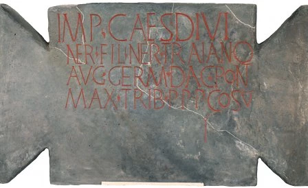
Building inscription from the south-east gateway.
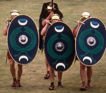
The site was explored in 1899-1901 by the Cardiff Naturalists' Society and then by John Ward, Curator of Cardiff Museum and Art Gallery, who undertook further excavations outside the fort between 1908 and 1913. The results established that the site was a Roman fort garrisoned by a cohors quingenaria (an auxiliary infantry unit of 500 men. The auxiliary infantry who garrisoned Gelligaer would have worn a simple mail shirt over a tunic, perhaps with trousers of wool or leather, and helmet. They would have carried a flat oval shield and been equipped with sword, dagger and stabbing-spear.)
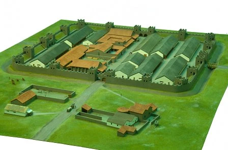
The fort was defended by a wide outer ditch and an earth rampart faced on both sides by a stone wall. There were corner and interval towers and four double-arched gateways. The impressive headquarters building stood at the centre of the fort and next to it lay the residence of the unit's commander. A workshop with a yard and two granaries completed the central range of buildings. The men lived in six barrack blocks, one for each century of 80 men and their centurion. Other buildings within the fort were probably used for stores and a stable for the baggage animals belonging to the unit.
Outside the fort on the south-east side was a walled extension containing a bathhouse, where the soldiers could relax when off duty. Attached to the fort was the parade ground, used for drill, weapons training and religious festivals.
Roman conquest
Model of the stone fort at Gelligaer in the early 2nd century AD.
The stone fort was not the first military base at Gelligaer. A large earthwork to the north-west was an earlier earth and timber fort, probably built at the time of the Roman conquest of Wales in AD74-8. It was replaced by the smaller stone fort sometime between AD103-111. We know this date because of the inscription from the south-east gateway was found during the excavations. It records the construction of the fort between AD103 and 111 during the reign of the Emperor Trajan. The text reads:
"For the Emperor Caesar Nerva Trajan Augustus, conqueror of Germany, conqueror of Dacia, son of the deified Nerva, High Priest, with Tribunician Power, father of his country, five times Consul, four times acclaimed Imperator, (the Second Augustan Legion [built this])."
Native rebellions
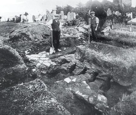
Excavation of the tile kiln at Gelligaer in 1913. Large quantities of brick and tile would have been needed during the construction of the fort.
The forts at Gelligaer were part of a military network across Wales which prevented any native rebellion. Gelligaer's nearest neighbours were forts at Pen-y-Darren to the north and Caerphilly to the south. Recent research indicates that the garrison was probably withdrawn at the time of the Emperor Hadrian (AD117-38), by which time the Silures had been pacified. There is evidence for later activity at the site, but its nature is unclear.
Background Reading
The Ermine Street Guard kitted as auxiliary infantryman.
The Roman fort of Gellygaer in the county of Glamorgan by John Ward. Published by Bemrose & Sons (1903).
Gelligaer Roman fort by Richard Brewer. Published by the National Museums & Galleries of Wales (1980).
Comments - (4)
Thank you for your enquiry.
The fort at Gelligaer is a Scheduled Monument, protected by law. Metal detecting is illegal on any Scheduled Monument, and certain other categories of site. Useful guidance can be found in the Code of Practice for Responsible Metal Detecting in England and Wales (2017).
Yours,
Evan
Look forward to you reply
Kindest Regard
Gavin
Hi Anne
I found this link, it might be helpful for you: Roman Fort Location
Sara
Digital Team