Although not competing with areas famous for their instability such as western California, Japan or Sumatra, Wales is a region of regular active Earth movements. You might be surprised to learn that at least sixteen significant earthquakes have occurred in Wales during the last century.

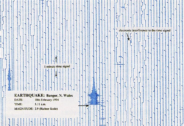
Seismograph showing an earthquake in north Wales in 1994
Why do earthquakes occur in Wales?
The British Geological Survey (BGS) records around 300-400 earthquakes each year in Britain. Wales, along with the rest of the UK, sits on the European plate, and stress builds up as it is pushed slowly north-eastwards from the Mid-Atlantic Ridge. The stress is released by movement along pre-existing fault planes, causing an earthquake.
Where do earthquakes occur in Wales?
There are several long-active fault systems in Wales. Once faults form, they create weak zones in the crust that can be reactivated time and time again. For example, the fault system running parallel to the Menai Strait between Anglesey and Bangor in north Wales are known to have been active over 500 million years ago and have also been the sites of more recent earthquakes.
The Menai Strait area is the most seismically active area in Wales and one of the most active in the UK. The last major earthquake occurred here in 1984, but many others are known from historical records (including 1827, 1842, 1852, 1874, 1879, 1903). Although many events have been recorded in south Wales, from Pembroke to Newport, only the Swansea area shows consistent activity, with significant earthquakes occurring in 1727, 1775, 1832, 1868 and 1906.
Largest earthquake in Wales for 100 years
The 1984, magnitude 5.4, Menai Strait earthquake was the largest onshore UK event for over 100 years. The epicentre was located in northern Llŷn, north Wales and the quake originated at a depth of approximately 22 km in the Earth's crust.
Another major UK earthquake occurred on 2 April 1990 in the Welsh Borders. This magnitude 5.1 event was felt over an area of approximately 140,000 square kilometres and was followed by six aftershocks. The epicentre was initially identified as being at Bishop's Castle in Shropshire, but this was later revised to a location just inside the Welsh border (latitude 52.43°' N, longitude 3.03° W).
Local damage
In both earthquakes the damage was relatively minor, including cracks in plaster and masonry and collapse of chimneys. In the Bishop's Castle event this was limited to the area immediately around the epicentre.
The only fatality known from any seismic activity in Wales is from a woman falling down the stairs and being killed during the Porthmadog earthquake of 1940.
Recent activity
An earthquake with a magnitude of 4.6 occurred in south Wales on February 17, 2018. According to the British Geological Survey (BGS), its epicentre was between Ystradgynlais and Ystalafera. A Welsh earthquake also occurred in the Bristol Channel on 20th February 2014, and was widely felt across South Wales, Devon, Somerset and western Gloucestershire. The BGS received several reports from the media and local residents describing “felt like the vibration of a large vehicle passing the building”, “the whole house seemed to move/wobble back and forth a few times”..
The magnitude 4.1 earthquake is the largest to hit South Wales since 2013.
Other recent earthquake activity from Wales include:
- A magnitude 3.8 earthquake on the Lleyn Peninsula on 29th May 2013.
- Magnitude 2.9 earthquake near Nantyffyllon on 5th June 2009.
- Magnitude 2.9 earthquake near Llangollen on 30th November 2007
- A magnitude 2.9 quake in Cardiff on 20th June 2002.
In general, humans cannot feel events of less than magnitude 2.
Recording earthqake activity at Amgueddfa Cymru.
A seismograph at National Museum Cardiff displays output from a local seismometer and allows observation of data from seismic events.
As seismometers are very sensitive to all types of ground vibrations, not only earthquakes but local traffic, trains and even roadworks, it was not possible to locate a seismometer in Cardiff city centre. Instead, data is obtained by a radio link from the nearest BGS seismometer near Newport, Gwent.
Glossary
- Aftershocks are earthquakes that follow the largest shock of an earthquake sequence; they are smaller than the main event and can continue for years afterwards. The length of the aftershock period relates to the magnitude of the main shock, with large events having more numerous and larger aftershocks for the longer periods.
- Epicentre this is the point on the Earth's surface above the earthquake hypocentre.
- Hypocentre this is the place deep in the Earth where the earthquake rupture starts.
- Intensity is a measure of an earthquake's effect on people and the environment. It is controlled by: the distance from the epicentre, the magnitude of the earthquake and the local geology. In Europe the 12 division EMS 98 (European Macroseismic Scale) is used and in the USA the Modified Mercalli Intensity Scale. For details of the EMS 98 see www.earthquakes.bgs.ac.uk/macroseismics/ems_synopsis.htm.
- Magnitude is a measure of the strength of an earthquake. This is a logarithmic scale, which means that for each whole number increase there is a ten-fold increase in ground movement. There are several types of magnitude scale, but the 'Richter Scale'(ML — magnitude local) is the one used most commonly in the UK for 'local' earthquakes.
- Plate. The outer layers of the Earth's crust and mantle are divided into segments known as plates, which are in constant motion. The process by which plates move is know as plate tectonics.
- Seismometers work by measuring the position of a weight, to which a coil is attached, relative to a magnet in a frame. Vibrations cause movement of the coil and the generation of an electrical current which is then recorded by a seismograph. Seismometers, are highly sensitive, and can record the slightest of movements that are totally unfelt by humans.
- Seismographs record the motion detected by the seismometer. This is either on a paper trace or as electronic data. Time markers record the precise time a seismic event reaches the seismometer. By using data from at least three seismographs the position of an earthquake can be calculated.
For current earthquake data see: http://earthquake.usgs.gov/earthquakes/ & http://www.earthquakes.bgs.ac.uk/ & http://www.emsc-csem.org/